During my trip to Korea I took the chance to visit the DMZ, the demilitarized zone which separates North and South Korea.
The DMZ is the buffer area between two nations which have remained officially at war with each other since the end of the Korean War in 1953, and still don't recognize each others' legitimacy. It is 4 km. wide and runs for 250 km., dividing the Korean peninsula in half. On either side of it lies a huge array of weaponry and military personnel, making it in fact the most heavily militarized border on earth.
The border area is not generally open to the public, but it is possible for tourists to visit the South Korean side as part of a tour (the Northern side is also included in tours of North Korea). Your passport is checked when you enter the DMZ, and it is necessary to book in advance, since only a limited number of people are allowed in every day.
The tour bus took me from my hotel in Seoul to the DMZ in less than an hour, bringing home to me how close this modern and glitzy metropolis is to a fortified border with an inscrutable and hostile dictatorship. To get into the DMZ we had to pass through a checkpoint full of young lads in uniform. South Korea has a mandatory two year military service for men, and it really is mandatory, with no provisions for conscientious objectors to fulfill some other kind of civil service like what used to happen in most European countries. This however is still much better than what goes on North of the border, where young men reportedly have to spend over ten years in uniform. That's North Korea for you.
The tour I went on included one of the four "infiltration tunnels" which the North Koreans dug into South Korean territory. These four tunnels have been discovered by the South at different points between 1974 and 1990. South Korea believes that these tunnels were planned as a route for an invasion, not altogether such a crazy idea. It also believes that another twenty such tunnels are still awaiting discovery.
The tunnel we were taken to see was discovered in 1978 after a tip from a defector. It extends about 1.7 kms into South Korean territory, and is about 73 meters deep. The site is only 44 kms from Seoul. Tourists access the tunnel through a long and steep incline built by the South Koreans, which starts in a lobby with a gift shop which bizarrely sells North Korean whiskey. You are not allowed to bring your phone or camera down with you.
The tunnel itself is quite narrow and the ceiling is so low down that I had to walk bending over, and I am not especially tall. The tunnel's walls were painted black, since the North Koreans made a clumsy attempt to pretend the tunnel was a coal mine before retreating. There is in fact no coal in the area. The South Koreans built three bunkers at the point directly under the Military Demarcation Line, the actual border between North and South. You can walk up to the first bunker, which has barbed wire and a machine gun in front of it, but no soldiers. After the three bunkers North Korea begins.
Another stop on our tour was an observation point from which you can get a clear view of the Northern side of the border, especially by using the telescopic lenses meant for visitors. The landscape looked pretty bleak, although that is to be expected during a Korean winter.From the observation post you could see the two so-called "peace villages", which were the only villages allowed to remain in the DMZ after the war. The two hamlets sit just across from each other, one on each side of the border.
Typically, the North Korean village is actually an empty shell built for propaganda purposes, although the DPRK government claims that it is a functioning collective farm. The buildings, which all have white walls and blue roofs, appear to be empty concrete shells, but the lights are turned on and off at set times to keep up the pretense that they are inhabited.
The village on the South Korean side is actually inhabited, and the locals apparently live there voluntary. They have an 11 PM curfew, but they are compensated for their inconveniences by being exempt from taxes and military service. Both villages have an absolutely gigantic flagpole in the middle, bearing the country's national flag at the top. It was the South which started this one in 1980, building a 98 mt. flagpole with its yin and yang flag at the top, to which the North responded with a 160 mt. flagpole, the tallest in the world at the time.
The last site we visited was the Dorasan train station. This station was once a stop on the railway which connected Seoul to Pyongyang before the country was divided. In 2007 part of this railway line was historically reopened, and trains coming from the South began to service the Kaesong Industrial Park, a joint industrial park set up North of the border which was run by South Korean companies but manned by North Korean workers. This project was a huge breakthrough in relations between the two countries when it began. It was also a great source of foreign currency for the North Korean regime.
The Kaeson Industrial Park was however shut down following the Korean crisis of 2013, when the North claimed that it was no longer constrained by the 1953 armistice (it has actually claimed this six times since 1994), and promised "merciless retaliation" against its enemies. The train line was also shut down, and the Dorasan station currently only receives tourist trains from Seoul.
The station gives the impression that it is kept running mostly in the hope of better times to come. There is a board which announces trains "to Pyongyang", something which has not been possible for over half a century and won't be for god knows how long in the future. There is also a ticket office which seems to be kept running mostly for show. A banner proclaims "not the last stop in the South, but the first stop to the North".
During the visit I saw no signs of US military presence, even though the US army helps guard the Southern side of the border. I wondered if they are deliberately kept out of sight, in order not to lend any fuel to North Korean propaganda about the Southern side of the peninsula being a "Yankee colony".
All the sites we were taken to had the unlikely feel of tourist attractions, with gift shops and the ever-present bus loads of Chinese tourists. However the huge military presence, the barbed wire and the observation posts served to remind us that this is actually one of the tensest borders in the world. Violence can and does flare up between the two sides. Last October, a group of North Korean soldiers were seen approaching the border and the South Koreans fired warning shots at them. They fired back before retreating, but luckily no one was hurt.
In spite of everything, the border is clearly not impregnable. A couple of years ago, a young North Korean soldier killed two of his superiors and defected to the South. He managed to cross the border undetected and had to knock on a South Korean barracks door to attract attention to himself.
The DMZ is the buffer area between two nations which have remained officially at war with each other since the end of the Korean War in 1953, and still don't recognize each others' legitimacy. It is 4 km. wide and runs for 250 km., dividing the Korean peninsula in half. On either side of it lies a huge array of weaponry and military personnel, making it in fact the most heavily militarized border on earth.
The border area is not generally open to the public, but it is possible for tourists to visit the South Korean side as part of a tour (the Northern side is also included in tours of North Korea). Your passport is checked when you enter the DMZ, and it is necessary to book in advance, since only a limited number of people are allowed in every day.
The tour bus took me from my hotel in Seoul to the DMZ in less than an hour, bringing home to me how close this modern and glitzy metropolis is to a fortified border with an inscrutable and hostile dictatorship. To get into the DMZ we had to pass through a checkpoint full of young lads in uniform. South Korea has a mandatory two year military service for men, and it really is mandatory, with no provisions for conscientious objectors to fulfill some other kind of civil service like what used to happen in most European countries. This however is still much better than what goes on North of the border, where young men reportedly have to spend over ten years in uniform. That's North Korea for you.
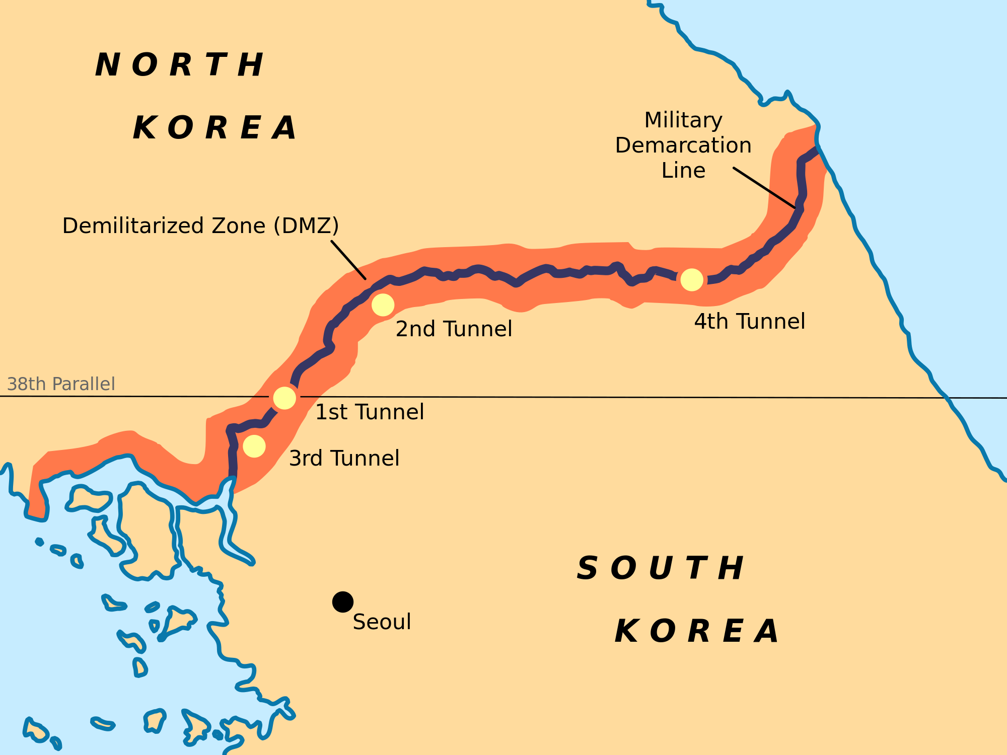 |
| Map of the DMZ with the four "infiltration tunnels" marked. I visited the third one. |
The tour I went on included one of the four "infiltration tunnels" which the North Koreans dug into South Korean territory. These four tunnels have been discovered by the South at different points between 1974 and 1990. South Korea believes that these tunnels were planned as a route for an invasion, not altogether such a crazy idea. It also believes that another twenty such tunnels are still awaiting discovery.
The tunnel we were taken to see was discovered in 1978 after a tip from a defector. It extends about 1.7 kms into South Korean territory, and is about 73 meters deep. The site is only 44 kms from Seoul. Tourists access the tunnel through a long and steep incline built by the South Koreans, which starts in a lobby with a gift shop which bizarrely sells North Korean whiskey. You are not allowed to bring your phone or camera down with you.
The tunnel itself is quite narrow and the ceiling is so low down that I had to walk bending over, and I am not especially tall. The tunnel's walls were painted black, since the North Koreans made a clumsy attempt to pretend the tunnel was a coal mine before retreating. There is in fact no coal in the area. The South Koreans built three bunkers at the point directly under the Military Demarcation Line, the actual border between North and South. You can walk up to the first bunker, which has barbed wire and a machine gun in front of it, but no soldiers. After the three bunkers North Korea begins.
Another stop on our tour was an observation point from which you can get a clear view of the Northern side of the border, especially by using the telescopic lenses meant for visitors. The landscape looked pretty bleak, although that is to be expected during a Korean winter.From the observation post you could see the two so-called "peace villages", which were the only villages allowed to remain in the DMZ after the war. The two hamlets sit just across from each other, one on each side of the border.
Typically, the North Korean village is actually an empty shell built for propaganda purposes, although the DPRK government claims that it is a functioning collective farm. The buildings, which all have white walls and blue roofs, appear to be empty concrete shells, but the lights are turned on and off at set times to keep up the pretense that they are inhabited.
The village on the South Korean side is actually inhabited, and the locals apparently live there voluntary. They have an 11 PM curfew, but they are compensated for their inconveniences by being exempt from taxes and military service. Both villages have an absolutely gigantic flagpole in the middle, bearing the country's national flag at the top. It was the South which started this one in 1980, building a 98 mt. flagpole with its yin and yang flag at the top, to which the North responded with a 160 mt. flagpole, the tallest in the world at the time.
The last site we visited was the Dorasan train station. This station was once a stop on the railway which connected Seoul to Pyongyang before the country was divided. In 2007 part of this railway line was historically reopened, and trains coming from the South began to service the Kaesong Industrial Park, a joint industrial park set up North of the border which was run by South Korean companies but manned by North Korean workers. This project was a huge breakthrough in relations between the two countries when it began. It was also a great source of foreign currency for the North Korean regime.
The Kaeson Industrial Park was however shut down following the Korean crisis of 2013, when the North claimed that it was no longer constrained by the 1953 armistice (it has actually claimed this six times since 1994), and promised "merciless retaliation" against its enemies. The train line was also shut down, and the Dorasan station currently only receives tourist trains from Seoul.
The station gives the impression that it is kept running mostly in the hope of better times to come. There is a board which announces trains "to Pyongyang", something which has not been possible for over half a century and won't be for god knows how long in the future. There is also a ticket office which seems to be kept running mostly for show. A banner proclaims "not the last stop in the South, but the first stop to the North".
During the visit I saw no signs of US military presence, even though the US army helps guard the Southern side of the border. I wondered if they are deliberately kept out of sight, in order not to lend any fuel to North Korean propaganda about the Southern side of the peninsula being a "Yankee colony".
All the sites we were taken to had the unlikely feel of tourist attractions, with gift shops and the ever-present bus loads of Chinese tourists. However the huge military presence, the barbed wire and the observation posts served to remind us that this is actually one of the tensest borders in the world. Violence can and does flare up between the two sides. Last October, a group of North Korean soldiers were seen approaching the border and the South Koreans fired warning shots at them. They fired back before retreating, but luckily no one was hurt.
In spite of everything, the border is clearly not impregnable. A couple of years ago, a young North Korean soldier killed two of his superiors and defected to the South. He managed to cross the border undetected and had to knock on a South Korean barracks door to attract attention to himself.
 |
| A photo I took of what could be seen of North Korea from over the border. Not very much, as you can see. |
2 comments:
Hi Ji Xiang,
How are you?:)
I was searching for Chinese learning online and found your article: http://thecapitalinthenorth.blogspot.com/2011/10/simplified-vs-traditional-chinese.html
It's funny. We are now making an infographic about Chinese learning. We are asking 30-50 bloggers the Top Three Resources they use to learn Chinese.A short feedback is good enough:)
Is it OK I send you an email?
Either way, thanks Ji Xiang. Have a nice week:)
Yang
Ok Yang Yang, leave me your email and I will send you a private message.
Post a Comment